Tuesday, October 7, 2008

Site 6: The Upstream Cracks


This is a quick little site to wrap everything up. Most of what is discussed here in a comparison of these cracks to the cracks at site two. Take a look a look at the posting for site two to refresh you memory. These cracks are wider, appear deeper, and the rock itself is much more rounded. The acid test revealed that this rock is limestone. The same test performed at site 2 yielded dolostone. Because limestone is more susceptible to chemical weathering by the acidic runoff, the rocks here show greater weathering, thus the larger cracks.

Site 5: The Stadium


Boy howdy, there is a lot to talk about here, two laws of geology, a principle, and joint caves, all set against the lovely backdrop of a waterfall and cliff.


First lets discuss the Law of Superposition. This law states that the oldest rock layer will be found on the bottom of a rock outcrop. That makes sense, have you even gone to a fair or carnival and made the different colored sand in the jar? Where is the sand you put in first? On the bottom! Looking at the large rock outcrop across the stream, the oldest layer is on the bottom and the youngest is on the top, this is a time span of millions of years of history.


Next we should talk about the Principle of Uniformity, which states that things happened in the past, the same way things happen today. The example we see at this site is ripple marks preserved in the rock. Here we see an example of sand ripples made in shallow tidal water at a beach. Yes, but what does it all mean? It means that geologists can infer the the environment in which some of the rock from this outcrop formed was tidal because it has ripples preserved in the rock.


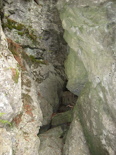
Lets pause for a minute from all these laws and principles to talk about joint caves. There are some delightful examples of joint caves at this location. Joint caves form when surface water soaks through the soil to the bedrock, then travels down through a joint crack until it reaches the bottom of the crack. At the bottom of the crack, the mildly acidic water begins to chemically weather the limestone. Over time the opening becomes larger and larger. If you look carefully at this picture you will see a vertical crack directly above the cave, that is the joint crack.


The last item to discuss at this station is the Law of Original Horizontality. This law states that sedimentary rock layers are all formed horizontally. When you see something different in a sedimentary rock (ie it is bent or folded) then there were tectonics forces at work on it.


Before we split, lets check out out escape route... straight up the joint crack.
Thursday, October 2, 2008

Site 4: Potholes


Wow, now this is a cool site. Check out these sweet potholes.
Not potholes like you see on the street, not even related. These potholes are formed when scouring stones are swirled by the water slowly grinding and polishing a hole into the rock.


We even have you folks practice making a pothole of your own. Good Luck!


Two things change dramatically at this site. The bedrock changes from the dolostone below to Limestone. This can be seen in the rounder and smoother shaping of the rock due to increased chemical weathering, and the gradient of the stream increases quite a bit.

Speaking of gradient we do another Jakestick activity here to measure the stream gradient. Gradient is important because it is what gives the water a greater velocity and more kinetic energy to create features such as potholes.

As an aside, across the stream under a tree, I like to refer to as the "tree of life", a good deal of water is pouring out. This is a very small cave. The water is runoff from upstream that has run into a joint crack to a joint cave. wha? check the video and see site 2 for information about joint cracks.

Sunday, May 27, 2007

Site 3: Boulder and Tree


At this site we discuss how limestone, a rock very resistant to physical weathering, is very easily weathered by chemical means. Acids from naturally occurring and man-made acid rain, as well as natural acids from the decomposition of leaf litter contributed to the solution channels we see across the top of this boulder.


Along the the side, there are several chert nodules that show differential weathering. Chert is a variety of quartz which is very resistant to physical and chemical weathering. Since it weathers more slowly, it sticks out.


At the very bottom of this boulder, we find a very interesting fossil of a cephalopod. This was a creature that looked much like a squid, but had a conical external shell. Cephalopods lived in warm, shallow tropical oceans. How is it that this area of NYS was once warm shallow tropical ocean? Plate Tectonics!


Across the stream we investigate a tree that appears to be growing out of the side of the cliff. Closer inspection reveals flattened roots that were shaped as they grew in cracks of the bedrock. As the roots grew, the wedged the rock apart, it was then eroded away by the stream.

Site 2: Swirls and Joint Cracks


Site 2 is really fun. Crayons and everything! At site 2 we investigate the very strange swirls in the surface of the rock. These are trace fossils of a sea floor dwelling worm called zoophycus that lived a long long time ago (Silurian) when this area was the bottom of a tropical ocean. This is not a fossil of the worm itself but of marks it left in the sediment.

The second item investigated at this site are the amazingly straight, amazingly parallel cracks in the bedrock. These are called joint cracks. They formed when the glaciers melted removing a great deal of weight from the surface of Earth. The continental ice sheets weighed so much they had pushed the crust down into the mantle. As the crust rebounded the cracks fromed from pressure unloading.

Site 1: Stream Gradient and Velocity


At site 1, we use Jake sticks and a tape measure to determine the elevation change and distance between to points. We use this information to determine the gradient at two locations. We then use a ping pong ball and a stop watch to measure stream rate. We compare the gradient and rate at two locations to see if there is a connection between the gradient and rate of the stream. We then use a chart from the Earth Science Reference Tables to determine the largest size sediment that could be moved by the stream a the given location, find a sediment that size, and experiment with it.

Gravel pit


This is the first station in the field study guide, although your group may not have started here. In fact you probably finished the trip here. This enitre station is located on top of a deposit of sediments left behind by a glacier. The sediments are mixed in size, varied in composition and origin, and sub-rounded in shape. Over at the outcrop, you can view an immature soil profile. The upper layer with roots, insect burrows, etc is a slightly darker color, this is due to the humus (decaying organic material) in the A Horizon. Below that, is a layer of broken up bedrock with no organic materials or minerals to speak of. This is called the C Horizon. There is no B horizon, that is because this sediment was deposited by the retreat of the glaciers at the end of the last ice age, approximately 15 to 12 thousand years ago. Top soil forms at an average rate of 1 cm per 400 years. There has not been enough time for a B-horizon to form. That is why this is called an immature soil profile.